

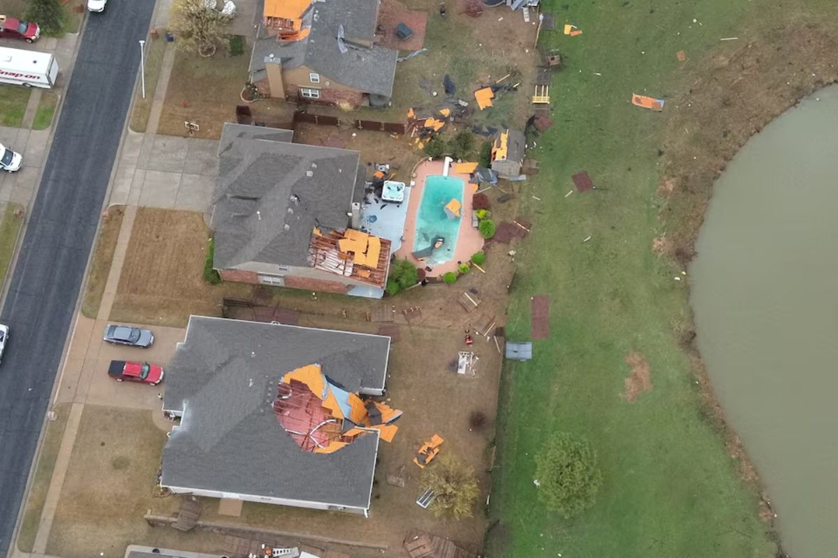
A strong storm system ripped over the South and Midwest, releasing many tornadoes, killing at least one person and causing significant destruction. The storms downed power lines, uprooted trees, and ripped roofs off homes, affecting millions across many states.
Tornado and Severe Storm Warnings Issued
Tornado Emergency continues for Moscow TN, Williston TN and Grand Junction TN until 2:00 AM CDT pic.twitter.com/HwHLFAkToI
— NWS Tornado (@NWStornado) April 3, 2025
A tornado forced the National Weather Service office in Paducah, Kentucky, to take shelter at 8:18 p.m. local time on Wednesday, while Missouri-based CBS affiliate KFVS-TV continued broadcasting as the storm passed directly over the station.
12:22 AM – FINALLY the NWS Paducah forecast area is in the clear for tonight with the exception of ongoing flash flooding in some areas. We have A LOT of damage surveys to do and have several planned for tomorrow and the days following. We will update with info when possible. pic.twitter.com/sxGCCIMmvZ
— NWS Paducah, KY (@NWSPaducah) April 3, 2025
Authorities issued hundreds of tornado and severe thunderstorm warnings over Arkansas, Illinois, Indiana, Missouri, and Mississippi as the storms worsened Wednesday evening. Meteorologists attributed the extreme weather to a volatile mix of daytime heating, strong wind shear, and moisture from the Gulf.
In southeast Missouri, at least one fatality was reported, according to KFVS-TV. In Indiana, part of a warehouse collapsed in a suburb of Indianapolis, temporarily trapping at least one person. A rare tornado emergency was also issued in northeast Arkansas as debris was sent thousands of feet into the air.
Deadly Flooding Threatens the Region
Forecasters warned that the storm system could produce deadly flash flooding in the coming days as it moves eastward. The National Weather Service (NWS) cautioned that “significant, life-threatening flash flooding” could occur daily through Saturday.
Rainfall totals exceeding 12 inches (30 cm) are expected over the next four days, making this a “once-in-a-generation to once-in-a-lifetime” event, according to the NWS. Flash flooding could be particularly severe in parts of the South and Midwest, with historic rainfall totals possible.
Millions at Risk as Tornadoes Touch Down
Here’s footage of the tornado on the ground in Walnut, Mississippi, heading toward Selmer, Tennessee.
McNairy County residents are urged to take shelter NOW.
(
: Tom Theil) pic.twitter.com/xxB13s15jf
— Action News 5 (@WMCActionNews5) April 3, 2025

More than 90 million people across a vast region from Texas to Minnesota and Maine are under threat of severe weather, according to the Storm Prediction Center.
A tornado emergency, the highest-level alert issued by the NWS, was briefly in effect near Blytheville, Arkansas, where debris was detected at least 25,000 feet (7.6 km) in the air. Another tornado touched down near Harrisburg, Arkansas.
Emergency management officials in Arkansas reported storm damage in 22 counties, with injuries and widespread destruction. In Kentucky, a tornado near Jeffersontown injured four people when debris struck a church. One person remains in critical condition.
Indiana saw a warehouse collapse in Brownsburg, leading authorities to urge residents to avoid travel. On Interstate 65 near Lowell, Indiana, strong winds toppled five semi-trucks. In Missouri, structures were damaged in Pilot Grove, with overturned cars and snapped power poles reported by emergency officials.
Widespread Damage and Power Outages
In eastern Missouri, authorities are assessing whether a tornado caused significant damage in and around the city of Nevada, where buildings were damaged, vehicles overturned, and power lines torn down.
In Oklahoma, a tornado struck Owasso, heavily damaging homes and infrastructure. Fortunately, no injuries were immediately reported.
Power outages affected nearly 90,000 customers across Arkansas, Mississippi, Missouri, Illinois, Kentucky, and Tennessee. As storms intensified Wednesday night, Indiana saw more than 182,000 power outages.
Long-Track, Powerful Tornadoes Still Possible
One of a million reasons I will never move back to the south.
This was in Arkansas today.
If you’re not familiar with tornado sizes – that’s a big fucking tornado. pic.twitter.com/pAhgmrCa4T
— Snark Queen Bee
(@SnarkQueenBee) April 3, 2025
Approximately 2.5 million people remain in a high-risk zone spanning parts of Tennessee, Arkansas, Missouri, Kentucky, and Illinois. The Storm Prediction Center warned of multiple long-track EF3+ tornadoes, which are among the most destructive types.
Major cities like Chicago, Indianapolis, St. Louis, and Louisville face a lower but still significant risk. Dallas, Detroit, Milwaukee, and Nashville also remain vulnerable.
Floodwaters Could Inundate Towns and Highways
Flash flooding has already begun, with heavy rainfall swamping streets in Indianapolis. Officials reported water nearly reaching the windows of vehicles, though no occupants were found inside.
The NWS warned that additional rounds of torrential rain are expected from Texas to the Ohio Valley through Saturday. The stalled front could result in repeated downpours over the same areas, increasing the risk of life-threatening floods.
Middle Tennessee is bracing for extended heavy rainfall, with meteorologist Mark Rose from the NWS stating, “I don’t recall ever seeing one like this in 30 years. It’s not moving.”
Rainfall could total up to 15 inches (38 cm) in the most affected areas, particularly in parts of Arkansas, Missouri, Kentucky, Illinois, and Indiana, leading to extreme flood risks.
Midwest Power Outages Persist
Meanwhile, Michigan continues to recover from a weekend ice storm. Over 122,000 customers remain without power, with crews working around the clock to restore service.
The Mackinac Bridge, a key connection between Michigan’s Upper and Lower Peninsulas, was closed for a third consecutive day due to ice falling from its cables and towers.
Stay Alert and Prepared
A powerful storm system raced over the South and Midwest, unleashing many tornadoes that killed at least one person and caused extensive damage. The storms damaged power lines, uprooted trees, and ripped roofs off homes, hurting millions in many states.


